Hurricane Laura Expected to Hit East Texas
2020 Just Keeps Getting Better and Better
By Will Johnson
Messenger Reporter
HOUSTON COUNTY – So far in 2020, Australia has burned, Kobe Bryant died, President Trump was impeached and then acquitted, murder hornets showed up, the Black Lives Matter movement was launched and COVID-19 has affected nearly every aspect of life. What’s next, you might ask?

In a meme just waiting to happen, Mother Nature said “Hold my beer! Have I got something for you,” and sent two tropical storms churning towards the Gulf Coast.
The first was Marco which, fortunately, weakened into a tropical depression by the time it hit land near the mouth of the Mississippi River. The second is Laura which has now strengthened into a hurricane.
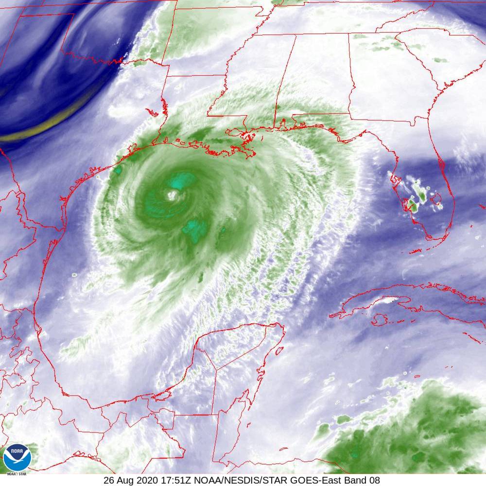
According to the National Weather Service (NWS), “Hurricane Laura continues its trek through the southern Gulf of Mexico. As of 10 am CDT (Aug. 25), Laura is moving west-northwest around 16 mph with maximum winds of 75 mph. Laura will be moving through an environment with favorable conditions for strengthening and is expected to become a major hurricane by landfall Wednesday night in either southwest Louisiana or Southeast Texas. Hurricane warnings are now in effect in the Galveston Bay area, as well as Polk County. A tropical storm warning covers much of the rest of Southeast Texas east of the Brazos River. The track has been slowly shifting to the west since yesterday and additional adjustments to the track may be necessary today. This may require additional warnings further down the Southeast Texas Gulf Coast.”
The NWS further stated, “The Tropical Storm Watch has been upgraded to a Tropical Storm Warning for Brazoria Islands, Inland Brazoria, Inland Harris, Montgomery, San Jacinto, Trinity, and Walker. A Tropical Storm Warning has (also) been issued for Fort Bend, Grimes, Houston, Madison, and Waller (Counties).
A Tropical Storm Warning means tropical storm-force winds are expected somewhere within this area within the next 36 hours.
During a Houston County Commissioners Court meeting held on Tuesday morning Aug. 25, Houston County Emergency Management Coordinator Roger Dickey stressed area residents need to start taking precautions now.
“It is continuing to track west which means it is getting closer and closer to us. We are expecting some wind damage, we will have some trees down and some power outage potential. This thing is looking a lot like (Hurricane) Ike did. You may remember the debris issues we had with Ike. There is still time for it to track one way or another but all the models are showing if there is any movement it will probably be more towards the west,” Dickey said.
He continued, “I went on the radio a little bit ago and told me to stay indoors during the worst of the storm. If people are calling and saying I have a tree down and can’t get out, I have told them, we are not coming out until it is safe to do so. The potential is there and we will continue to monitor it.”
Traffic throughout the Houston County area is already starting to pick up as residents flee the coast line and head north. Some areas are already under mandatory evacuation orders and almost all hotel rooms in both the Crockett and Palestine areas have already been booked.
Houston County School Superintendents are meeting on Wednesday afternoon to discuss the plans for their districts.
Will Johnson may be contacted via e-mail at [email protected].